The well detail screen is the key place to find any and all information about a particular well, and is organized in tabs along the left side of the screen. The well details are great anytime you want to dig into a single well and get a full picture of the story a well has to tell.
You can reach this screen from nearly a dozen locations within WellDatabase. The Map and Well List are two of the most common, but there are many more.
- Clicking a well spot from the map will give you the option to open the well details
- Click the well name from the list will take you directly to the well details.
So what data do we show in the well detail page? Let's dig in to the data available in the various sections.
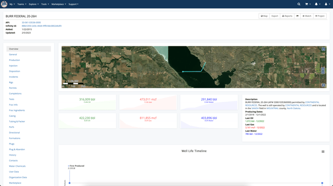
Overview
The overview tab contains a very quick look at the high level information for a well, including a satellite view of the wells location, cum volumes, producing dates, operator information, a timeline of the activity of the well. The data here is great for a quick look at a well.
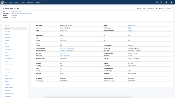
General
The general tab contains a more detailed view of the basic well header information. Well name, API, lease name, operators, depths, first and last activity dates, location data, and more are all visible in one place here.
Production Data
Production data is available on the well level here and includes both a chart and a table of the data. You also have the ability to run a decline curve on this well from the chart.
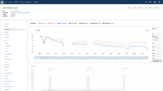
There are numerous options and tools for this chart. To read more about those, see What can I do on the production charts?
Gatherer Data
While the well that we are reviewing the well details for in this article does not have any gatherer data, we do present a message to reflect that there is no data available.

Here is an example of a well that does contain gatherer data.

Injection Data
Much like production data, injection data includes a chart as well. It is key to note that both pressures and volumes are plotted here.

Below the chart is a exportable table containing the details from the chart.

Disposition Data
Disposition data includes details such as: volumes of oil transported via truck, the amount of gas that is flared, gas directed to pipelines, and gas utilized on-site, among other related metrics.

Incident Data
The incidents tab will include any environmental incidents that have been collected for the well. The types of incidents include leaks, blowouts, fires, spills, and other documented events that impact the environment.

Rig Data
Rig data will include the report date of the rig, and target depth ranges of the rig.

Permit Data
The permits tab will show the permits available for the well, and include the permit number, available dates for when it was submitted, approved, expires, and/or amended. In addition, there is a placeholder for the permit status and purpose. 
Completions Data
The completions tab will present any completions available for the well and present available data on the completion including: dates, operator, field, completion purpose and type, depths, perfs, and more.

Test Data
Test data include the dates, hours of the test, daily rates, gravities, pressures, temperatures, and more. For a complete list of data points available for test records, you can learn more in the following article: What data is contained in the Test Records?

Frac Info
Frac info will show the operator, service company, start/end dates, depths, volumes, mass, primary proppant material, and more.

Frac Ingredients
Quickly see a list of ingredients used in the Frac. To see a full list of data points available for Frac Ingredients, click here.

Frac Stages
Frac stages will show details about each stage, including dates, stage, top, bottom, volumes, mass, primary proppant material. Here is a complete list of data points available for Frac Stages.

Casing
The casing data will include wellbore size, upper and lower depths, cement stacks, casing weight and size.

Tubing & Packer
In the Tubing & Packer tab, you will find the completion date, tubing size, upper and lower tubing depth, as well as the packer depth.

Perfs
Easily access the upper and lower perfs directly on the well details. Additional data points are available in the Perf Record.

Directional
In the directional tab, you can explore a 3D diagram that illustrates "this well" alongside its neighboring wells. Below the diagram, there is an exportable table that provides a detailed, step-by-step account of the well's directional information. If you are interested in a more comprehensive examination of this data, we offer an article that thoroughly explains this tab, click here to explore the directional tab in detail.

Formations
In the formations section, you can access key information including the reported formation name, its top depth, and any relevant comments that have been documented.

Interpreted Formations
Explore the interpreted formations record.

Plugs
The plugs section provides an overview of the plug type, the depth of the lower plug, and the amount of cement used.

Plug & Abandon
For wells that have been plugged and abandoned, locate the date it was plugged and the mud weight.

History
History records contain additional information available on wells, view the effective dates, operator, field, and comments in the history tab.

Cores
In the Core section, you will discover information regarding core types, formation, top and bottom depths, as well as any comments related to the cores.

Water Chemicals
The water chemicals section provides an overview of the water samples cataloged in the USGS water database. In this part of the well details, you will be able to access important information such as the USGS ID, completion date, sample date, analysis date, specific gravity, chemical composition, measurement units, and the amounts.

Well Location
The Well Location Record will show the coordinates as they were reported, the EPSG column contains a unique 4-5 digit code that represents the CRS. While WellDatabase uses EPSG:4326/ WGS-84 CRS, in the well location record, we will present the location information as reported.
Locate the location type (surface or bottom hole), status, lat/long, Epgs, Wgs 84 lat/long, and the address including city, state, and postal code.

Activity
The activity tab serves as a useful resource for tracking updates related to this well. Here, you can find detailed information about the timing and nature of changes made to various records, including files, production data, permits, and other relevant updates.

Files
In the files tab, you will be presented will our library of publicly available records for a single well. You can view or download documents directly from this page. File formats can include tiff, pdf, and las.

Additional Data
-
- Contacts
- Core Analysis
Advanced Data
There are a few additional data tabs available to users, depending on their plan levels and setup.
-
- User Data
- Organization Data
Marketplace
The marketplace tab will show you available products to purchase from 3rd party vendors.
-
- Marketplace
List View
In addition to exploring well details one by one, these details can also be viewed in the list view for all the wells in your search by changing the "Show" from the default of headers to another record type. Learn more about what you can do with the lists, click here.

Explore other articles by searching the topics on the left or if you have any questions feel free to email support@welldatabase.com