This comprehensive set of measurements captures the precise path taken during a directional survey, allowing engineers and geologists to analyze and understand the trajectory of a wellbore.
Use the directional records to gain valuable insights into the well's position and orientation at various depths. These measurements are crucial in ensuring that the wellbore does not intersect with nearby wells, while also accurately determining the exact location of the bottomhole.
To access this information, navigate to the Well Details Card, and then choose the directional tab on the left side-panel.

Directional Tab
Let's look at what is contained in the directional tab of the well detail card.
Toolbar
![]()
![]() = Show Settings
= Show Settings
In the settings you can choose to add or remove elements in the drawing.

Top, Bottom, Front, Back, Left, Right, Bore End will change the angle of viewing the directional drawing. Or you can reset back to the original view.
Base Image
Red Line: This well
Green Lines: Offset wells
Blue Hexagon: Surface Hole
Yellow: Hover on a map element
Example Well: Bender 14-6H

Perfs/Depth Markers: Red circles around the well line

Blue Arrow: There is a 360 view of the directional drawing, and as you move the image around, the blue arrow will appear to show "North". The examples below how North is still represented as you rotate the image.


Show Axes or Grid
Blue: Longitude (North/South)
Red: Latitude (East/West)
Green: Elevation / Depth


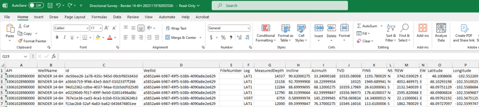
Directional Survey
The directional survey data is shown below the drawing, providing a wealth of valuable information. These step-by-step measurements include the inclination, azimuth, and each survey point, offering detailed insights into the trajectory of the wellbore.

Export Data
In addition to viewing this information in the Directional tab of the Well Detail Card, you can export the data points of the directional survey to Excel or CSV using the Data Export Wizard.