Access bottom hole settings through the map tools panel. Below are the options for visualizing bottom hole locations on the WellDatabase map.
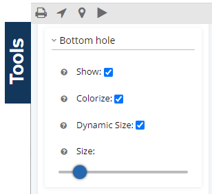
- Show – Simple toggle to hide/show bottom hole locations. This defaults to on.
- Colorize – Toggle to color well spots by the property selected for Color By in the Group Settings
Note: If toggled off, the well spots will be black. - Dynamic Size – Toggle to use the Size By (again in Group Settings) property to dynamically size the well spot.
- Size – Base size of the well spot. If Dynamic Size is selected, the smallest values will have the size specified and larger values will be exponentially larger. If Dynamic Size is not selected, the size value will be the size (in pixels) of the well spot.