WellDatabase includes dozens of built in overlays. We’ll review the overlays and the sources in this support article.
Find the Overlays
Open your 'Tools' panel to the right of the map and in the 'Layers' section, click the plus ![]() button.
button.

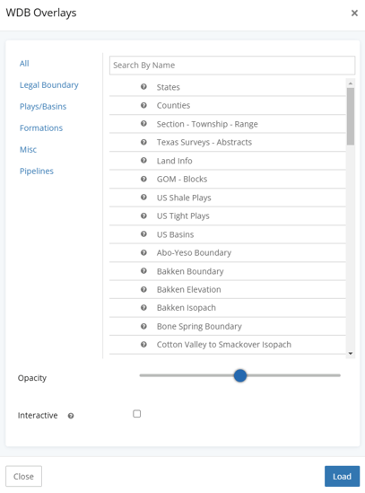
Choose the WDB Overlay

Once you open the WDB Overlay selector, you will see the overlays, organized by types. By default the view is "All" overlays. Adding an overlay to the map from this section is as easy as clicking the layer you want to see, modifying the opacity if desired, and clicking the Load button.
Clicking Load will dismiss the selector and your overlay will immediately appear.
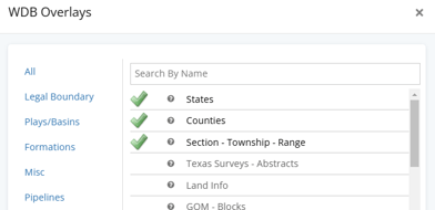
You can also select multiple overlays at once like below, and each will be loaded as a separate layer.
Legal Boundary
The legal boundary settings includes various publicly available boundary overlays.
-
- States
- Counties
- Section, Township, Range
- Surveys & Abstracts (Texas)
- Land Info
- GOM - Blocks
- Pennsylvania Municipality Boundaries
- Kentucky Carter Grid
Plays/Basins
The plays/basins section contains overlays that are created from shapefiles obtained from the EIA data portal.
-
- US Shale Plays
- US Tight Plays
- US Basins
- Delaware Boundary
- Midland Boundary
- Palo Duro Basin Boundary
- Val Verde Basin Boundary
- Marathon Ouachita Thrust Belt
- Central Basin Platform Boundary
- Capitan Reef Trend Boundary
- Permian Northwest Shelf Boundary
- Matador Arch Boundary
- Ozona Arch Boundary
- San Simon Channel Boundary
- Sheffield Channel Boundary
Note on Plays/Basins: These boundaries are also the boundaries used in the Play / Basin Extents filter. Applying the filter with the overlay together help understand the geographical boundary that is being used.
Formations
Formation overlays are more detailed overlays, also originating from the EIA published data. You’ll find boundaries, elevations, isopachs, and more.
-
- Abo-Yeso Boundary
- Bakken Boundary, Elevation, or Isopach
- Bone Spring Boundary
- Cotton Valley to Smackover Isopach
- Eagle Ford Boundary, Elevation, or Isopach
- Glorieta Yeso Boundary
- Marcellus Boundary, Elevation, or Isopach
- Niobrara Boundary, Elevation, or Isopach
- Point Pleasant Elevation or Isopach
- Sprayberry Boundary
- Three Forks Boundary or Elevation
- Utica Boundary, Elevation, or Isopach
- Wolfcamp Boundary, Elevation, or Isopach at 200' or 400' interval
- Wolfcamp A Elevation or Isopach
- Wolfcamp B Elevation or Isopach
- Wolfcamp Shelf Margin Boundary
Misc
The misc section contains less conventional overlays. Faults are from USGS, All Wells will allow you to see all well spots as a background layer on your map, Gas Processing Plants are another from the EIA that shows spots for the gas processing plants across the us, and Railroads are, well, railroads.
-
- USGS Quaternary Faults
- Permian Basin Faults
- All Wells
- GOM Platforms
- Gas Processing Plants
- US Railroads
Pipelines
Pipelines are another EIA provided overlay. They control the classification and naming of the pipeline overlay.
-
- Crude Oil Pipelines
- Detailed Texas Pipelines
- Natural Gas Pipelines
- NGL Pipelines
- HGL Pipelines
- Petroleum Product Pipelines
- GOM Offshore Pipelines
Explore other articles by searching the topics on the left or if you have any questions feel free to email support@welldatabase.com